


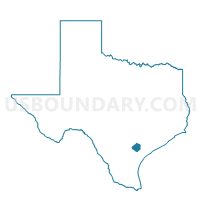
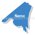
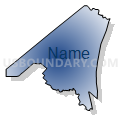
Voting District 0033, Goliad County, Texas
About
Outline

Summary
| Unique Area Identifier | 673399 |
| Name | Voting District 0033 |
| County | Goliad County |
| State | Texas |
| Area (square miles) | 104.51 |
| Land Area (square miles) | 104.28 |
| Water Area (square miles) | 0.23 |
| % of Land Area | 99.78 |
| % of Water Area | 0.22 |
| Latitude of the Internal Point | 28.82639270 |
| Longtitude of the Internal Point | -97.45194670 |
Maps


Graphs
Select a template below for downloading or customizing gragh for Voting District 0033, Goliad County, Texas


Neighbors
Neighoring Voting District (by Name) Neighboring Voting District on the Map
- Voting District 0005, Karnes County, TX
- Voting District 0006, DeWitt County, TX
- Voting District 0007, DeWitt County, TX
- Voting District 0023, DeWitt County, TX
- Voting District 0031, Goliad County, TX
- Voting District 0032, Goliad County, TX
- Voting District 0041, Goliad County, TX
Top 10 Neighboring County Subdivision (by Population) Neighboring County Subdivision on the Map
- Goliad North CCD, Goliad County, TX (4,454)
- Yorktown CCD, DeWitt County, TX (4,107)
- Westhoff-Arneckville CCD, DeWitt County, TX (2,138)
- Weesatche-Ander CCD, Goliad County, TX (1,738)
- Runge CCD, Karnes County, TX (1,430)
Top 10 Neighboring Unified School District (by Population) Neighboring Unified School District on the Map
- Goliad Independent School District, TX (7,210)
- Yorktown Independent School District, TX (3,510)
- Runge Independent School District, TX (1,326)
- Meyersville Independent School District, TX (1,194)
- Nordheim Independent School District, TX (702)
Top 10 Neighboring State Legislative District Lower Chamber (by Population) Neighboring State Legislative District Lower Chamber on the Map
Top 10 Neighboring State Legislative District Upper Chamber (by Population) Neighboring State Legislative District Upper Chamber on the Map
Top 10 Neighboring 111th Congressional District (by Population) Neighboring 111th Congressional District on the Map
Top 10 Neighboring Census Tract (by Population) Neighboring Census Tract on the Map
- Census Tract 9601, Goliad County, TX (4,054)
- Census Tract 9704, DeWitt County, TX (3,704)
- Census Tract 9602, Goliad County, TX (3,156)
- Census Tract 9704, Karnes County, TX (1,430)
Top 10 Neighboring 5-Digit ZIP Code Tabulation Area (by Population) Neighboring 5-Digit ZIP Code Tabulation Area on the Map
- 77963, TX (5,459)
- 78164, TX (3,796)
- 78151, TX (1,347)
- 78141, TX (596)
- 77974, TX (455)
- 77993, TX (148)